The Hague Residential Districts
A brief The Hague overview with information and demographics for each of the city’s 8 residential districts including number of residents, access to public transport, green areas, schools and more.
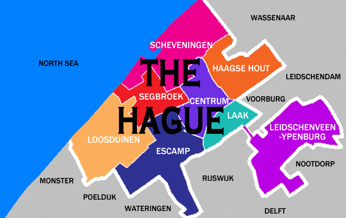
THE HAGUE OVERVIEW
The following is a brief The Hague overview. Get to know each of the 8 districts that make up the third largest city in Netherlands. Besides ‘The Hague’, the city is also referred to in Dutch as Den Haag or more formally as ‘s-Gravenhage…
The Hague is 98.13 km2 in area and is the most densely populated city in Netherlands with 6,861 residents/km2.
The average age of a Hagenaar (resident of The Hague) is 39.2 years. 63.2% are between the ages of 20-64 years, 21.8% between 0-19 years and 15% are age 65 or over.
There are 284,014 households in The Hague which is a 7.2% increase over the past 5 years. This outpaces the population growth of 5.6% over the same period.
Home prices fell to their lowest levels following the 2008-2010 recession. In 2012 the average home valuation in The Hague was €175,000. Since then, prices have risen significantly. In 2023 the average home in The Hague was valued at €363,571.
THE HAGUE RESIDENTIAL DISTRICTS
Planning a move to The Hague? Familiarize yourself with the city’s eight urban districts before deciding where to live. Make sure an area covers your needs in terms of access to public transportation, green spaces, sports facilities, etc. For expats moving with children, close proximity to an international school may be important.
THE HAGUE CENTER
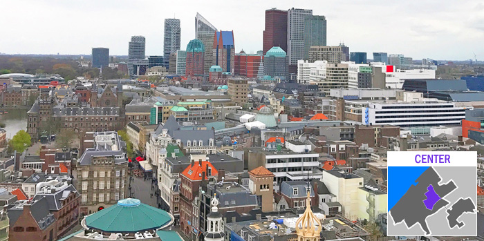
The Center (Urban District 5) is the oldest part of the city, with some portions dating back to the 13th century. 110,339 residents (19.6% of the total) lives in the Center. Culturally, it is the most diverse area of The Hague with 76.3% of the residents having an international background. The remaining 23.7% are native Dutch. Neighborhoods in this district include some of the city’s lowest-income (Schildersbuurt, Transvaalkwartier) and highest-income (Archipelbuurt-Willemspark, Zeeheldenkwartier) areas. The Center is the best-served district in terms of public transportation, with trains, buses and trams easily accessible. Landmarks include the Binnenhof (Dutch Parliament building), Noordeinde Palace, Peace Palace, Grote Kerk, Stadhuis (City Hall), Central Station, HollandsSpoor station and the city’s tallest buildings. The Center is the city’s least green district with only the Palace Gardens park located in it.
Resident Age Groups
- Age 0-19 years: 20.1%
- Age 20-64 years: 67.9%
- Age 65+ years: 12.0%
Avg Household Income: €41,371
- Low Income: 57.7%
- Middle Income: 29.4%
- High Income: 12.9%
Households: 57,915
- 1-person 55.1%
- 2-person 20.5%
- 2-person with children 16.0%
- 1-person with children 8.5%
Housing Breakout
- Owned Homes: 26.5%
- Social Housing: 42.0%
- Private Rental: 30.5%
Housing Type
- House: 12.6%
- Apartment: 84.8%
Avg WOZ Home Value: €334,608
Crime
- Criminal Offenses: 12,158
- Nuisance Offenses: 8,277
City Hall: Spui 70
ESCAMP
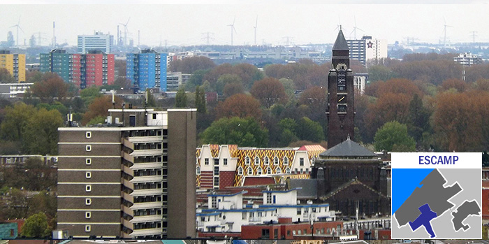
Escamp (Urban District 2) has grown significantly since the end of WWII. It extends from the Rustenbuurt-Oostbroek neighborhood on the north to Wateringse Veld on the south and from Moerwijk on the east to Bouwlust-Vrederust on the west. Located in Escamp are two of the city’s largest recreation areas: Zuiderpark (including the ‘Sportcampus‘ complex) and De Uithof, as well as the Leyweg Winkelcentrum (shopping center) and Juliana Children’s Hospital. Escamp has more residents (130,811) than any other district, accounting for 23.2% of the city’s population. 67.4% of residents have an international background while 32.4% are native Dutch. Public transportation options in Escamp include train (Moerwijk station), trams and buses. This district borders the neighboring cities of Wateringen and Rijswijk.
Resident Age Groups
- Age 0-19 years: 24.1%
- Age 20-64 years: 63.1%
- Age 65+ years: 12.8%
Avg Household Income: €39,239
- Low Income: 54.7%
- Middle Income: 33.6%
- High Income: 11.7%
Households: 64,434
- 1-person 46.8%
- 2-person 20.1%
- 2-person with children 22.0%
- 1-person with children 11.1%
Housing Breakout
- Owned Homes: 37.3%
- Social Housing: 45.8%
- Private Rental: 16.7%
Housing Type
- House: 20.1%
- Apartment: 79.5%
Avg WOZ Home Value: €270,380
Crime
- Criminal Offenses: 7,777
- Nuisance Offenses: 4,691
City Office: Leyweg 813
HAAGSE HOUT
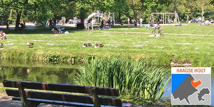
Haagse Hout (Urban District 7) is one of the city’s greenest districts, with the 100-hectare (247 acres) Haagse Bos (The Hague forest) extending from the city center to the Wassenaar border. It is home to 9.0% (50,598) of city residents, of which 52.2% have an international background and 47.8% are native Dutch. Two of The Hague’s wealthiest neighborhoods- Benoordenhout and Marlot– are located in this district, along with Haagse Bos, Mariahoeve, Bezuidenhout and the Beatrixkwartier. Notable landmarks include the royal family’s residential palace, Huis ten Bosch, the Clingendael estate, Louwman Automotive Museum and the World Trade Center The Hague. Public transport includes train (stations Laan van N.O.I. and Mariahoeve), tram and bus. International schools include branches of the HSV (primary) and the British School (primary). The Haagse Hout district borders the neighboring cities of Leidschendam, Voorburg and Wassenaar.
Resident Age Groups
- Age 0-19 years: 19.7%
- Age 20-64 years: 61.1%
- Age 65+ years: 19.2%
Avg Household Income: €54,079
- Low Income: 40.2%
- Middle Income: 36.2%
- High Income: 23.6%
Households: 27,361
- 1-person 52.2%
- 2-person 24.6%
- 2-person with children 16.7%
- 1-person with children 6.6%
Housing Breakout
- Owned Homes: 50.9%
- Social Housing: 20.2%
- Private Rental: 28.5%
Housing Type
- House: 15.0%
- Apartment: 82.7%
Avg WOZ Home Value: €431,795
Crime
- Criminal Offenses: 2,879
- Nuisance Offenses: 1,630
LAAK
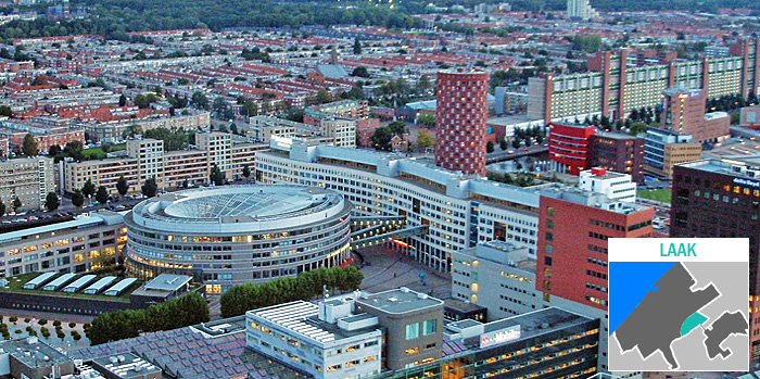
Laak (Urban District 6) is the smallest in area and population, with 8.2% (46,256) of city residents. It is comprised of three neighborhoods: Binckhorst, Spoorwijk and Laakkwartier. At the beginning of the 20th century, Binckhorst was primarily an industrial area where the gas factory was located. Since the Millennium, the city has slowly been redeveloping it and the rest of the Laak district to make it more livable. Demographically, 79.1% of district residents have an international background while 20.9% are native Dutch. Landmarks include The Hague University of Applied Sciences, Megastores shopping mall and Binck 36, the former headquarters of Dutch telecommunications company PTT. The Laak district borders the neighboring cities of Voorburg and Rijswijk.
Resident Age Groups
- Age 0-19 years: 20.9%
- Age 20-64 years: 70.9%
- Age 65+ years: 8.2%
Avg Household Income: €35,534
- Low Income: 58.2%
- Middle Income: 34.5%
- High Income: 7.3%
Households: 25,165
- 1-person 52.2%
- 2-person 21.8%
- 2-person with children 17.0%
- 1-person with children 9.0%
Housing Breakout
- Owned Homes: 28.8%
- Social Housing: 31.8%
- Private Rental: 38.8%
Housing Type
- House: 9.8%
- Apartment: 83.2%
Avg WOZ Home Value: €246,369
Crime
- Criminal Offenses: 3,504
- Nuisance Offenses: 1,680
LEIDSCHENVEEN-YPENBURG
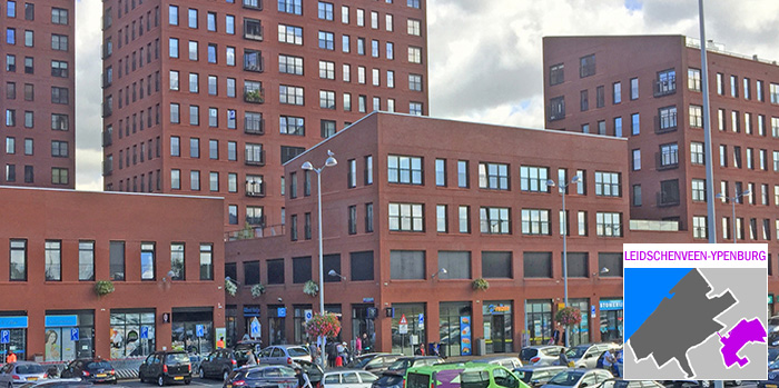
Leidschenveen-Ypenburg (Urban District 8) became part of The Hague in 2002 when the land was annexed from the neighboring municipalities of Leidschendam, Nootdorp and Rijswijk. Leidschenveen ìs built on the site of a former air field. The district is home to 8.6% (48,463) of the city’s residents of which 53.6% have a native Dutch background and 46.6% have an international background. The neighborhoods of Forepark and Hoornwijk are also part of Leidschenveen-Ypenburg. The district has four distinct quadrants due to two major motorways that intersect (the A4 running north-south and the A12 running east-west). Landmarks in Leidschenveen-Ypenburg include the Cars Jeans Stadium, Drievliet amusement park and the Leidschenveen campus of the British School (primary/secondary).
Resident Age Groups
- Age 0-19 years: 28.3%
- Age 20-64 years: 61.6%
- Age 65+ years: 10.1%
Avg Household Income: €62,314
- Low Income: 24.5%
- Middle Income: 37.7%
- High Income: 37.8%
Households: 18,626
- 1-person 24.8%
- 2-person 22.7%
- 2-person with children 41.6%
- 1-person with children 10.9%
Housing Breakout
- Owned Homes: 61.2%
- Social Housing: 26.5%
- Private Rental: 12.2%
Housing Type
- House: 74.6%
- Apartment: 24.7%
Avg WOZ Home Value: €474,812
Crime
- Criminal Offenses: 1,904
- Nuisance Offenses: 846
LOOSDUINEN
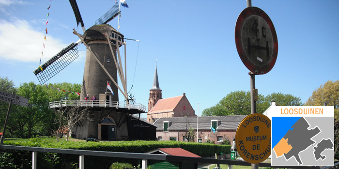
Until its annexation in 1923, Loosduinen (Urban District 1) had been a separate municipality. It is located on the southwest side of the city and includes the neighborhoods of Kijkduin-Ockenburg, Kraayenstein-De Uithof, Bohemen and Waldeck. It is home to 9.4% (52,737) of The Hague’s residents of whom 63.8% are native Dutch and 36.2% have an international background. Loosduinen has the highest penetration of senior citizens (27.6%). Landmarks in this district include the Kijkduin beach strand, De Savornin Lohmanplein winkelcentrum (shopping center), the International School of The Hague (primary/secondary) and the Ockenburgh and Madestein recreation areas. Loosduinen borders the neighboring towns of Poeldijk and Monster.
Resident Age Groups
- Age 0-19 years: 19.4%
- Age 20-64 years: 53.0%
- Age 65+ years: 27.6%
Avg Household Income: €45,183
- Low Income: 45.1%
- Middle Income: 38.9%
- High Income: 16.0%
Households: 26,257
- 1-person 46.0%
- 2-person 25.9%
- 2-person with children 19.8%
- 1-person with children 8.4%
Housing Breakout
- Owned Homes: 51.2%
- Social Housing: 32.3%
- Private Rental: 15.4%
Housing Type
- House: 30.7%
- Apartment: 69.0%
Avg WOZ Home Value: €361,308
Crime
- Criminal Offenses: 2,948
- Nuisance Offenses: 1,979
SCHEVENINGEN
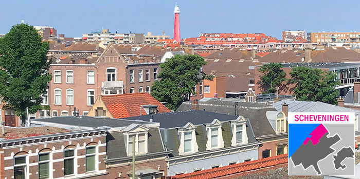
Scheveningen (Urban District 4) is located along the North Sea coast. It includes the neighborhoods of Oostduinen, Belgische Park, Westbroekpark, Van Stolkpark, Scheveningen, Statenkwartier, International Zone and Duindorp. Along with Haagse Hout, it is the city’s greenest district with the 92 hectare (227 acre) Scheveninges Bosjes, the 46 hectare (113 acre) Westbroekpark and the 20 hectare (49 acre) Nieuwe Scheveningse Bosjes. Many attractions and landmarks are located in Scheveningen including De Pier and the Skyview Ferris Wheel, Kurhaus Hotel, Scheveningen Lighthouse, Kunstmuseum Den Haag and Madurodam theme park. 10.8% (60,869) of city residents live in this district; 60.8% have a native Dutch background while 39.2% have an international background. Public transport is available by tram and bus.
Resident Age Groups
- Age 0-19 years: 20.6%
- Age 20-64 years: 59.6%
- Age 65+ years: 19.8%
Avg Household Income: €56,203
- Low Income: 40.2%
- Middle Income: 34.7%
- High Income: 25.1%
Households: 31,512
- 1-person 47.6%
- 2-person 26.1%
- 2-person with children 19.3%
- 1-person with children 7.0%
Housing Breakout
- Owned Homes: 54.3%
- Social Housing: 17.2%
- Private Rental: 27.4%
Housing Type
- House: 22.4%
- Apartment: 76.6%
Avg WOZ Home Value: €505,620
Crime
- Criminal Offenses: 3,097
- Nuisance Offenses: 2,281
SEGBROEK
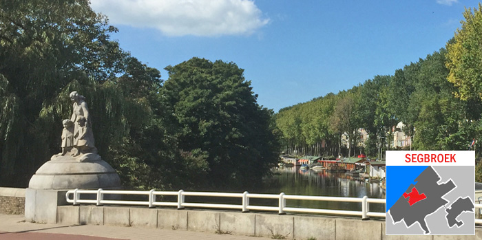
Segbroek (Urban District 3) is west of the city center and includes the neighborhoods of Bomen & Bloemenbuurt, Regentessekwartier, Valkenboskwartier, Vruchtenbuurt and Vogelwijk (one of the city’s wealthiest areas). It is home to 11.2% (63,049) of The Hague’s residents who are 56.5% native Dutch and 43.4% non-native Dutch. The popular shopping streets ‘The Fred‘ (Fahrenheitstraat), Thomsonlaan and Reinkenstraat are located in Segbroek as is the European School of The Hague (primary/secondary). Green areas include Bosjes van Poot. Public transport is by tram and bus.
Resident Age Groups
- Age 0-19 years: 20.4%
- Age 20-64 years: 64.3%
- Age 65+ years: 15.3%
Avg Household Income: €48,535
- Low Income: 41.1%
- Middle Income: 38.1%
- High Income: 20.8%
Households: 32,744
- 1-person 47.1%
- 2-person 25.1%
- 2-person with children 19.8%
- 1-person with children 8.0%
Housing Breakout
- Owned Homes: 58.0%
- Social Housing: 9.6%
- Private Rental: 32.1%
Housing Types
- House: 16.4%
- Apartment: 82.7%
Avg WOZ Home Value: €403,267
Crime
- Criminal Offenses: 2,931
- Nuisance Offenses: 2,081
City District Office: Fahrenheitstraat 190
All figures shown are based on 2023 data unless noted otherwise.
Related information…